Convolutional Neural Network to Retrieve Water Depth in Marine Shallow Water Area From Remote Sensing Images
2020年5月28日· ,,,,,·
0 分钟阅读时长
,,,,,·
0 分钟阅读时长
艾波
Corresponding
,Zhen Wen
Zhenhua Wang
Ruifu Wang
Dianpeng Su
Chengming Li
Fanlin Yang
摘要
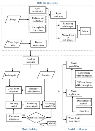
The local connection characteristics of convolutional neural network (CNN) are linked with the local spatial correlation of image pixels for water depth retrieval in this article. The method has greater advantages and higher precision than traditional retrieval methods. Traditional remote sensing empirical models require manual extraction of retrieval factors and the process is complex. This article proposes a model based on CNN, which uses different remote sensing images in four spectral bands, red, green, blue, and near-infrared, to retrieve the water depth. In general, CNN is mostly used for image recognition and classification tasks, which can make full use of the local spatial correlation between pixels. The method in this article exploits this feature of CNN for water depth retrieval, taking into consideration the nonlinear relationship between the radiance value and water depth value from adjacent and central pixels. In this article, remote sensing image data, measured water depth data, and lidar sounding data are used as input data to build the model. Then, the retrieval error is analyzed and the parameters are adjusted to further optimize the model. Quantitative analysis and experimental results show that the accuracy of the CNN model in shallow sea areas retrieval is improved by more than 50%. The mean absolute error can reach within 0.8 m. Finally, the model is shown to be highly portable and capable of retrieving water depth data with resolution equal to the spatial resolution of the remote sensing image using only a small amount of input water depth data.
类型
出版物
IEEE Journal of Selected Topics in Applied Earth Observations and Remote Sensing
Convolutional Neural Network (CNN)
Deep Learning
Shallow Water
Remote Sensing Images
Water Depth Retrieval
Spatial Correlation
海洋数值模式

Authors
正教授
山东科技大学测绘与空间信息学院教授、博士生导师,地理信息科学系主任。山东省泰山产业领军人才、2022年中国青年测绘科技创新人才、2019年山东省青年“互联网+”新锐人物。2005年获武汉大学地图学与地理信息系统硕士学位,2011年获山东科技大学大地测量学与测量工程博士学位,现任中国地理信息产业协会教育与科普工作委员会委员。主要从事“互联网+海洋”研究,主持国家自然科学基金(面上、青年)、国家重点研发计划、863计划等国家级课题10余项,发表论文70余篇(其中SCI论文30余篇为第一/通讯作者)。研发海洋大数据管理、防灾减灾、三维可视化等软件平台,应用于国家海洋环境预报中心、自然资源部北海局等单位。成果中国近海动力参数长期预测及应用系统研发获地理信息科技进步二等奖(第一完成人),另获测绘科技进步一等奖、海洋科学技术奖二等奖等省部级奖励9项。指导学生连续三年获全国GIS应用技能大赛特等奖,个人获全国高校GIS青年教师讲课竞赛一等奖。2020年主持建设地理信息科学国家级一流本科专业,2024年获评山东科技大学教书育人楷模。
Authors
Authors
Authors
Authors
Authors
Authors