Spatiotemporal dynamics analysis of aquaculture zones and its impact on green tide disaster in Haizhou Bay, China
摘要
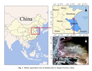
With the rapid marine economic development, the problem of the marine ecological environment has become progressively prominent. Mariculture monitoring plays an essential role in sustaining ecological stability, rational planning, and green economic development of sea areas. Using the Landsat image, the raft-mariculture area information of Haizhou Bay and its adjacent southern waters were extracted by the object-oriented classification method based on remote sensing techniques. Landscape pattern index and principal component analysis were used to analyze the spatiotemporal expansion and structural changes of mariculture areas, and to quantify the effects of natural, socio-economic factors on the spatiotemporal variations of mariculture areas. This study discusses the correlation between the mariculture area and the outbreak scale of Enteromorpha Enteromorpha green tide. Results show that the object-oriented classification method has the highest accuracy, with total classification accuracy and Kappa coefficient of more than 90% and 0.79, respectively. The total area, patch density, and landscape shape index of mariculture areas in Haizhou Bay increase yearly, which demonstrates that the heterogeneity and fragmentation increase with the expansion of the mariculture area. The landscape pattern changes in the mariculture area are predominantly impacted by annual mean sea surface temperature (SST), annual average wind speed, social development level, and population density, etc. The larger the area of raftaquaculture, the wider the outbreak scale of the Enteromorpha prolifera disaster. Study results can provide scientific references for the further development of mariculture in Haizhou Bay and marine environmental protection.
类型
出版物
Marine Environmental Research
Mariculture Area
Object-Oriented
Spatiotemporal Dynamics
Driving Force
Enteromorpha Prolifera
海洋数值模式

Authors
正教授
山东科技大学测绘与空间信息学院教授、博士生导师,地理信息科学系主任。山东省泰山产业领军人才、2022年中国青年测绘科技创新人才、2019年山东省青年“互联网+”新锐人物。2005年获武汉大学地图学与地理信息系统硕士学位,2011年获山东科技大学大地测量学与测量工程博士学位,现任中国地理信息产业协会教育与科普工作委员会委员。主要从事“互联网+海洋”研究,主持国家自然科学基金(面上、青年)、国家重点研发计划、863计划等国家级课题10余项,发表论文70余篇(其中SCI论文30余篇为第一/通讯作者)。研发海洋大数据管理、防灾减灾、三维可视化等软件平台,应用于国家海洋环境预报中心、自然资源部北海局等单位。成果中国近海动力参数长期预测及应用系统研发获地理信息科技进步二等奖(第一完成人),另获测绘科技进步一等奖、海洋科学技术奖二等奖等省部级奖励9项。指导学生连续三年获全国GIS应用技能大赛特等奖,个人获全国高校GIS青年教师讲课竞赛一等奖。2020年主持建设地理信息科学国家级一流本科专业,2024年获评山东科技大学教书育人楷模。
Authors
Authors
Authors
Authors